Description
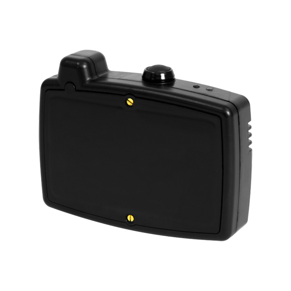
NAViSEER Personnel Tracking System is an inertial navigation device with optional GPS capability. NAViSEER utilizes the latest technology and provides an interface for integration with both civilian and military GPS devices. By blending GPS and inertial navigation technology, NAViSEER is continuously calibrated for the user’s stride length and body offset. This calibration enables up-to-date movement parameters when the user enters a GPS-denied or GPS-limited area and the DR device takes over.
The NAViSEER is a miniature, self-contained, electronic navigation unit for personnel on foot that provides user position relative to an initialization point. The initialization point can be provided by an attached GPS device or inputted by the user. Once an initialization point is configured, the relative position of the user is updated at user defined intervals on a visualization software display in the Command and Control (C2) Center.
In a burning 10 story building scenario, an entire Fire Battalion might be engaged. In many cases, a 7 man extraction team is positioned very near the scene, but remains otherwise unengaged unless a firefighter goes down. Once a firefighter is down, there is often no more than 3 minutes to get him/her out before it becomes a body extraction/recovery operation.
In many cases, the firefighter wears a Personal Alert Safety System (PASS) on their jacket. If a firefighter goes down, he/she hits a button on their PASS which sets off an audible alarm and a flashing strobe; however, there is nothing to indicate their exact location or even what floor they might be on. Seventeen lives were lost in 2007 that have been potentially attributed to PASS system failures, or the inability of the extraction teams to find the firefighter in time.
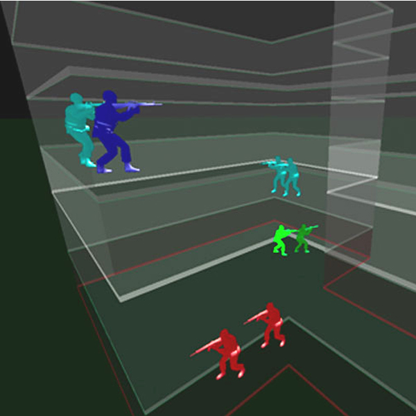
With the NAViSEER Personnel Tracking System, the GPS initialization point might be established at the Command and Control (C2) vehicle. From there, all NAViSEER-equipped firefighters could be tracked to their close approximate position on a specific floor as long as their radio equipment could still communicate with the C2. A 2D or 3D visualization console is implemented within the C2 vehicle that allows controllers to visually track the movement and pinpoint the location of the NAViSEER-equipped firefighters at all times.
Our own SEER 3D software provides stunning console views of movement and location of NAViSEER-equipped personnel. This visualization software can combine with or overlay available Geographical Information System (GIS) application information on the C2 monitors that receive the current position messages from the NAViSEER units attached to the firefighters. If their radios fail, the extraction team would at a minimum have a last known good position or last transmitted position from which to start their search.
There are biometric sensors available that can be interfaced/integrated with the NAViSEER. If that were the case in this scenario, the backup or rescue team would be able to tell if the downed firefighter was alive or potentially unconscious and unable to use his radio and could direct the appropriate response precisely to his/her position.
The NAViSEER rate of error is no more than 2% of distance traveled from the initialization point. This means that if the user is in a GPS-denied or GPS-limited area and travels 100 meters, the user position is known to no more than a 2 meter radius around the displayed position, based on the initialization point or last known good point. The vertical or altitude accuracy is not dependent on time or distance and the maximum error is less than 1.4 meters. Therefore, no matter how long or far the user has traveled in a GPS-denied or GPS-limited area, as long as the location signals can be transmitted back to the C2, the user position and altitude will be known.
Unlike other inertial navigation systems, the NAViSEER’s error characteristics are independent of time, and instead, depend primarily on distance traveled. With NAViSEER, advanced motion classification algorithms analyze movement and compensate when the user is moving backwards, sideways, running, crawling, or just fidgeting in place.
The NAViSEER can be directly interfaced to most digital radios and GPS receivers – and optionally can be ordered with an internal GPS receiver. NAViSEER is a reliable GPS supplement for personnel on foot.
The result of the SEER advancements in inertial navigation tracking is accurate positioning to within 2% of distance traveled – a capability not found in any other small scale, portable device. Successful systems integration of inertial navigation in past programs has demonstrated that a reliable navigation supplement for personnel does not require sensors on the legs or feet, and can readily co-exist with equipment normally carried by a soldier or other user.
NAViSEER devices provide real time location data via radio back to C2 computers equipped with Geographical Information Systems (GIS)-based 2D or 3D visualization software. SEER3D software instantly generates 2D and 3D views of buildings and structures that reveal graphical visualization of movement and location for assets equipped with NAViSEER.
Specifications
| Technology | MEMS sensors continuously update user’s position in GPS-denied areas Embedded SiRFstarIII with active antenna Distinguish walking, crawling, sideways and backward movement Visualize persons orientation in SEER3D After action review and data analysis Auto position connection when GPS is available |
| Communications | RS232C, PPP, IP-stack Transmit position data on existing wireless communication system User selectable position update rate Compatible with most digital radio systems eg Thales, Harris, Selex and Motorola |
| Protection | 1000 pounds crush force, water resistant to 10 feet |
| Operating Temperature | -5º to 140ºF |
| Power | 8 – 12 hours continuous operation, 2.5 hours to charge |
| Weight | 5.4 ounces |
| Size | 3.1″ x 1.5″ x 4.4″ |
Ordering Information
For pricing, please call AFC International at 1-800-952-3293, 219-987-6825 or fax 219-987-6826 or email [email protected].
